
Being a bit of a greenie at heart (before it was trendy) he has chosen the most eco-friendly method to be buried upright at the Kurweeton Road Cemetery, North of Camperdown, 1.5 hour drive West of Geelong.
Unlike traditional funerals there is no official service or funeral director speaking but friends and families are encouraged to share stories, memories or read a letter before the interment.
John has also requested no traditional funeral wear, instead dress to suit the cold countryside this time of year and wear a Flanno and Blundstones (flannelette shirt and boots), his favourite comfy clothes.
You're welcome to bring a flower to leave at the burial site but please nothing that isn't biodegradable like plastic wrapping.
.
Burial:
Thursday 28th May at 11:00am Kurweeton Road Cemetery
776 Kurweeton Rd, Derrinallum VIC 3325
(1.5 hours West of Geelong)
Please note:
No toilets at the cemetery, the last public toilet (or cafes etc) is in Derrinallum if you're traveling via the Hamilton Highway.
Refreshments:
Devonshire Tea and refreshments afterwards at Lake Edge Cafe
658 Purrumbete Estate Road, Lake Purrumbete VIC 3260
(Half hour drive from Kuweeton Rd Cemetery)
.
Here are some of his unsorted photos and memories over the recent decades and some more recent photos here , also his favourite music mix and even his old DOS Computer Games.
.
.
Links:
uprightburials.com.au
Kurweeton Road Cemetery
Photos
Photos
Lake Edge Cafe
Favourite Music
DOS Computer Games
.
.
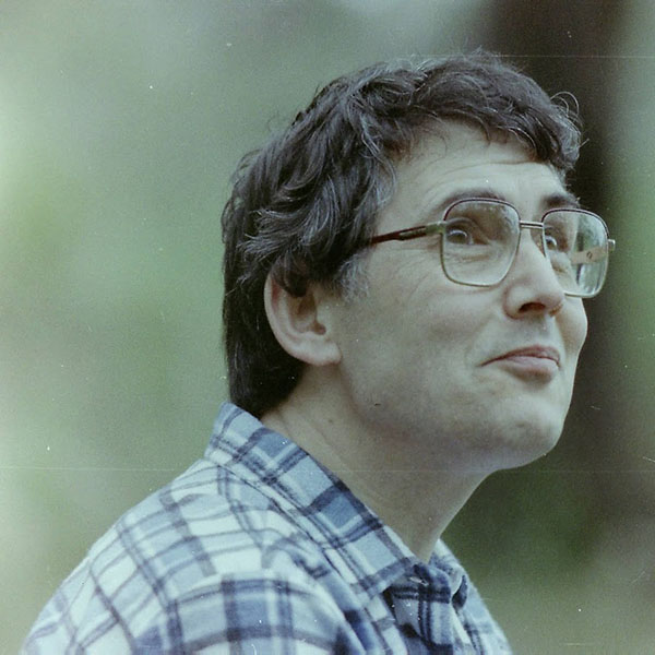
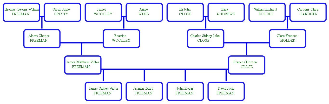
John - the author of this Freeman Family Tree website (below) which will be continued by Zed Freeman, his Grandson going forward.
Data for the Census of England, Wales, Scotland, Channel Islands and Isle of Man was collected at 10-year intervals on varying dates:
Dates shown like 9/8/1945 come from actual documents recording the event, so are generally accurate. For dates before 1837, when civil registration began, "birth" dates reflect baptisms, and death dates reflect burials.
Dates shown like Q3 1870 (3rd quarter) come from Births, Marriages and Deaths indexes, but represent the date the event was registered, so might lag the actual event.
Dates shown like 1732, or sometimes 1731/2 are implied from ages shown in marriage, burial, and census records, so are possibly a year out. An additional source of error is that ages were often not known with certainty, or were deliberately falsified.
Comparing the buying power of historical amounts to todays money depends on how you measure it. This table shows what one pound represents today via two measures: retail price index and average earnings.
| Year | RPI | Wages |
|---|---|---|
| 1750 | 133 | 1740 |
| 1775 | 108 | 1490 |
| 1800 | 68 | 1040 |
| 1825 | 69 | 761 |
| 1850 | 90 | 720 |
| 1875 | 80 | 454 |
| 1900 | 92 | 360 |
| 1925 | 48 | 155 |
| 1950 | 29 | 81 |
| 1975 | 7 | 11 |
| 2000 | 1.43 | 1.48 |
CORSE, a parish in the lower division of the hundred of
Westminster, in the county of Gloucester, 4 miles E. of Newent, and 6
N.W. of the Gloucester railway station. The parish contains Corse
Lawn, which was until 1790 a large common of nearly 1,400 acres, when
it was enclosed by act of parliament, and now produces plentiful crops
of grain, &c. The living is a vicarage* in the diocese of Gloucester
and Bristol, value Ł443, in the patronage of the lord chancellor. The
church, dedicated to St. Margaret, is partly in the Gothic style, and
contains monuments. The charities amount to Ł25 per annum. The
Wesleyans have a chapel, and there are National schools for both
sexes. George Dowdeswell, Esq., is lord of the manor. To the E. of the
village is Corse Hill, where a beautiful view may be obtained of the
surrounding country. Corse Court is a fine old mansion, once the seat
of Speaker Dowdeswell.
- The National Gazetteer of Great Britain and Ireland (1868)
CRANHAM, a parish in the hundred of Rapsgate, in the county of
Gloucester, 6 miles N.E. of Stroud, and 7 S. of Gloucester. The
inhabitants are chiefly engaged in agriculture and in the large
earthenware manufactory, known as the Potteries. The living is a
rectory in the diocese of Gloucester and Bristol, value with the
rectory* of Brimpsfield, Ł410, in the patronage of W. Goodrich,
Esq. The church is dedicated to St. James. There is a small chapel for
Baptists, and a National school. J. W. Lyon, Esq, is lord of the
manor.
- The National Gazetteer of Great Britain and Ireland (1868)
PAINSWICK, a parish, post, and market town in the hundred of Bisley, county Gloucester, 3˝ miles N.E. of Stroud railway station, and 6 S.E. of Gloucester. It is situated near the line of the Bristol and Birmingham railway, and the high roads from Cheltenham to Bath, and from Stroud to Gloucester, pass through it. The parish contains, besides the town of its own name, the tythings of Edge, Spoonbed, Shepscomb, Stroud End, and the hamlet of Slad. The manor is mentioned in Domesday-Book as Wiche, among the possessions of Roger de Lacy, and the prefix to its name came from Pain Fitz-John, one of its subsequent proprietors. It afterwards became the property of the Kingstons and Jerninghams.
It is governed by constables and tythingmen, chosen annually at
the court-leet of the lord of the manor. The town, which stands on
the declivity of Spoonbed Hill, is well built, and presents an
uniform and substantial appearance, the houses being chiefly built of
white stone, the produce of the neighbouring quarries. On the summit
of Spoonbed Hill is Kimsbury Roman encampment, with, a double
entrenchment, and at the foot runs a branch of the Stroud river. From
the heights above the town an extensive view of the Severn valley is
obtained.
- The National Gazetteer of Great Britain and Ireland (1868)
ULEY, a parish in the upper division of Berkeley hundred, county
Gloucester, 2˝ miles N.E. of Dursley, its post town, and 4 S. of the
Frocester railway station. The village is situated among the hills, on
the turnpike-road leading from Berkeley to Stroud and
Cheltenham. There is an iron foundry. In the vicinity is Uley-Bury, a
double-ditched camp of above 30 acres, where coins of Antonine and
other Roman emperors have been discovered. The living is a rectory* in
the diocese of Gloucester, value Ł157. The church, dedicated to
St. Giles, contains several monuments. There are day and Sunday
schools for both sexes. The parochial charities produce about Ł8
yearly. The Independents, Wesleyans, and Baptists have chapels. A
feast is held on the first Sunday in September.
- The National Gazetteer of Great Britain and Ireland (1868)
UPTON, (or Upton St. Leonards) a parish in the middle division of Dudstone hundred, county Gloucester, 3 miles S.E. of Gloucester, its post town, and S from Cheltenham. The village is situated on the road between Gloucester and Painswick. At a little distance from the village, on Painswick Beacon, is a Roman camp. The soil is chiefly a strong clay, but in some parts it is sand, stone brash, or gravel.
You can contact us via Roots Chat
Send a personal message to ferret999.
This site is kindly sponsored by CoffeeSnobs